The sights of the Autonomous Badakhshan Mountainous Province
The branches of the Silk Road is in Badakhshan
The routes of caravan roads crossed along the Badakhshan from the ancient times. They had not only the impotence of the economic and strategic meaning but they connected the cultures and religion of civilizations which lived across the “Silk” highway.
The shortest sections of the Silk Road crosses through the Southern Pamirs connecting Balkh and Fayzebad, and then conditionally “Shughnan” and “Wakhan” branches with the Middle East and Western world with “the mysterious country of Serov” and China.
The investigators divided the routes of the “Silk Road” into two branches:
Wakhan branch: “Kuhilal – Vrang – Ishkashim – Langar – the valley of the Wakhandarya river (Afghanistan) – Tashkurghan (China). For instance Austrian traveller and ethnographer Aural Stain mentions “the main road which connects the Western Asia, and, therefore the classical world of the deep Central Asia and Far East”.
Shughnan branch: the way from Balkh and Fayzebad (Afghan Badakhshan) through the lake of Shiva to the valley of Gunta and through Alichur to Yarkend – the only way crossing Pamirs in a large distance (Barpanja – Khorogh – Murghab - Tashkurgan). It is possible to explore a numerous fortresses possibly built for the protection of the caravans on one hand and on the other hand they were the outpost of the Great Powers.
The gret numbers of the fortresses are located on the upper land of Panj on the section of the Wakhan way and among them the most monumental fortresses are – Kahkaha and Yamchun which had state status.
Kahkaha fortress (III BC – VII AD)
Kahkaha fortress is one of the ancient and the best preserved fortified constructions of Wakhan which is located on the right bank of Panj and a kilometer from the Namadgut settlement (probably the name of the settlement is taken from the Sanskrit word “namat” – sacred, “gata” – place, which confirms the nearby holly mazar (tomb) Hazrat – Shihi – Mardon).
The fortress has an elongated shape (from the west to the east 675 m and from the south to the north 225 m); fitting into the terrain of the place and with its narrowing valley on an isolated two-humped cliff, the southern slope breaks off to the Panj side.
The construction is divided into two parts – northern, southern and the citadel, each of which is surrounded by fortified walls made of raw bricks and blocks (pressed clay) with stone fundament. There are 60 round, oval and rectangular towers with loopholes built around the fortress.
The walls are solid and doubled with the corridor – transition width of 2 – 2, 5 m and transverse walls dividing them into the separate compartments with 15 m length. Evidently the second walls had loopholes looking to the side of the fortress probably in any case for the intrusion of the opponents inside and the compartments of the corridor in that case could become the additional protection.
It is possible to enter into the citadel from northern or from the southern parts. This part of the fortress is strategically important. It has four rows of decorated raw bricks from the outside and upper part of the walls below 45 degree and also with protruding corners; a semicircular niches are laid upper with décor of bricks outgoing from the rays of the triangular center. Initially such plastic wall treatment concerning the game of light and shade was really effective. The tower above Panj has a wonderful shape and almost 6 m of it is preserved until today. Its powerful walls are cut like arrow loopholes and the analogies of them are possible to find in the ancient Khorezm and Parthian of Iran.
The citadel has a complicated shape like other fortresses – 200-40 m, which has a small plain ground with two premises.
The ancient architects had left signs on the big raw bricks (40x40 x10 cm) of the bastion (a circle inscribed with crosses, triangles and ovals) which are named tamga and has a great scientific significance. According to a version they were drawn as the genus signs, according to another versions they for brick counting. The signs of one`s hand is spread as a symbol all over the Mountainous Badakhsan.
Yamchun fortress (III c. BC – VII c. AD)
The Yamchun fortress is famous among the locals as the fortress of Zamr Fire worshiper (the fortress of fire worshipers), is located in the Yamchun settlement 3 km from the Vrang settlement. It occupies adjacent to the Wakhan ridge with a huge triangle cliff formed by two small mountain rivers Yamchun and Vichkut and it is one of the gigantic fortification premises of the Western Pamirs. The place where the fortress is built covers by slopes and terraces descending down and drops off steeply from the riverside thus creating a natural protection.
Yamchun fortress also consists of three walled areas like the Kahkaha fortress: below, middle, the biggest which has the form of triangle facing with its wide base to the valley and the citadel taking a flat top of this triangle. The difference between the elevation marks of the fortress and its base is equal to 300 m.
One of the interesting and impressive architecture of Yamchun is the triangle citadel which is possible to reach over the narrow trail from the north and west. In this part of the walls a powerful square tower is protruding with 6 m base tapering towards the top up to 1.3 meters. A 9 meter wall with parapet has preserved till today.
The surrounding walls of the citadel are built with carefully processed flat stones and fixed with clay. The towers of the citadel are two-storied and circle. The highest of them is 4 m, three-storied with loopholes, which are set up in staggered order 10 meters at the entrance of the bastion of the western part.
The size and the scales of the fortress and the defensive capacity are amazing until today. The length of the walls is 900 m from the south and western part of the fortress and the width of it is about 400 m. There are three powerful defensive lines are built for the intrusion of the enemies from the valley. Besides that there were special defensive towers with corridors and premises along the walls with loopholes. The enemies will never intrude but if intrudes otherwise they would be defeated.
The Vrshimkala fortress
The fortress of Vrshimkala is located not far from the colorful canyon near the Temple of fire on a rocky cliff over the Zong village. This fortress is one the most interesting fortresses of Wakhan. The name of that fortress is probably taken from a word “vrshim” which means silk and this is the evidence of those caravans with loads of precious cloths passing by and greeting from the long past.
It is possible to observe the mesmerizing view of the valley and merge of the Panj and Pamir River together above the fortress. The scenery of the fortress is beautiful on one hand and it is also strategically good for the fortress itself on another hand.
Vrmishka has enough preserved. It has a rectangle shape with three meter walls. There are rectangle premises coming out to the long corridors, leading to the exit by perimeter which once upon a time had a tower. It is possible to find premises with two rooms consisting of a hall (3x9m) and dwelling parts (1.5x5 m) reminding about the residential houses of Badakhshan – wide and multifunctional clay made sufas across the walls and the remnant of the ladder-shaped covers and so on.
Defensive and religious complex of Kafir Kala
The defensive and religious complex of Kafir Kala is located at the banks of Gunt River, at the top of a picturesque rock massif in the Bogev settlement. The complex consists of two religious buildings and the system of defensive premises.
Kafir Kala (which translated “The fortress of infidels”) came to our days with the form of the stone built fortresses on a top of a flat rock. The citadel with a row of defensive premises and 1.5 m wall from the eastern part built with blocks of stones without any cement with rectangle loopholes. The northern part of the fortress had the natural protection from the edge of the cliffs and the half ruined square premises like a defensive tower is on a small hill. Probably its role was for alarming from the height of the Gunt valley and at the entrance of the Bogevdari valley and also the way to the Shohdara valley which is the birth place of lapis lazuli everything is visible from the top.
Besides that the fortress served as the Pre-Islamic temple. According to the expedition group lead by the archaeologist M. Bubnov (1976-1983) there was found a round building 11 m with 100 square meter and inside it along the wall there was built a sufa 0.5 m high and 0.6 m width similar to a platform.There was a rectangle fire place, the edges which had been covered by clay made blocks. Here, two stones were built into the wall inlays on the south and west sides, the third was located in the front wall. Three oval and small utility buildings were adjoined to the north and eastern part of the temple perhaps they served for meal during the religious holidays.
Another round temple with a diameter of 9.6 m, area 72, 35 sq. m was excavated several ten meters away from the first temple on the lower terrace. The shapes of the temples and their internal parts allowed the archaeologists to relate this construction to the temples of fire. Perhaps it was used for fire worshiping and praying for the sun, although we can`t exclude the use of the sun as a calendar.
Rosht kala fortress
Rosht – Kala (the Rosht fortress) is located 5-6 km on the right bank of the Shohdara River and has a strong prolate shape to the north and southern direction; built with broken stones without cement. Once it had three towers and there were rectangle residential buildings 7,6x7 m on its upland. Although there are the remnants of the traditional Badakhshani houses were found at the eastern part of the fortress.
The Deruj fortress (Djaukhangoz)
Like all Pamir fortresses the Deruj fortress is located at the banks of the Djaukhangoz river on a rocky slope. As a classical fortification Deruj was has a rectangle shape with the territory of 600 sq. m and high fortified walls (60-65 m width), the base is laid up with large river pebbles and the upper part with raw bricks. Three adjacent rectangle towers with narrow loopholes are preserved at the south and western part of the fortress. The rest parts of it, including the remnant of two buildings are preserved partially.
The pier of Darkisht caravanserai
The Wakhan Corridor was popular and used regularly by variety of merchants and travellers in the medieval and for its confirmation there is an original premises which got its name by the archaeologist, candidate of science and the honored citizen of GBAO Mir Bubnov as the pier of caravanserai Darkisht. It is a diamond-shaped building surrounded by fortified walls with a yard and eight round towers. Inside them there were oval and rectangle rooms with fireplaces like corridors adjacent to the walls and also there were sufas along the walls probably were used for loading goods. The building was protected by southern towers and the rest of it was defended by numerous loopholes from the side of the valley. The fortress was built with stones and raw bricks.
The ancient settlement of metallurgist (X-XII c.)
The estate of Varshez (XI-XII c.)
This residential complex was excavated in 1972 on the upper side of the Gunt River not far from the Varshez village Shighnan district (the Varshez settlement 1-4). So, Varshez I were the stone made settlement with 700 sq. m which has long corridors leading to the residential building with traditional step-like ceiling chorkhona, sufas and fireplaces. The Varshez III is situated on a hill at the left bank of Tokuz-Bulak River. It is surrounded by walls and has a central entrance with a small corridor and the second entrance is located on the opposite side. The territory of the complex is 1000 sq. m consisting of residential and dwelling buildings. The southern house (central place in the composition) is connecting both entrances with four adjacent premises and the bid square building has a traditional construction with a platform in the center and fireplace. The ceiling is step-like with a small lightning in the top. The estate of Varshez IV consists of 20 adjacent premises connected to the center of the complex. There was a canal beside the the estate.
The Chartem estate IV (X-XI c.)
The ruins of Chartem is near the Chartem settlement behind a small lake beneath of the Shughnan ridges. The gigantic settlement of metallurgists is spread from the east to the west. The rectangle buildings had two routes of parallel streets from the north to the south. The main parts of the constructions consist of rectangle buildings connecting separate dwelling houses with two or three rooms. There are four other separate buildings at the eastern part of the settlement.
Bazardara the city of silver miners (XI c.)
Bazardara the city of silver miners is located at the right bank of Ak-Djilga river, 6 km from its confluence with Bazar-rik river. Bozordara was founded in the XI century on the elevation of 1800 m because of the silver extraction mines during the “silver crisis” in the Eastern Pamirs. Bazardara existed about 200 – 250 years. However in this short time it could grow up into a big caravanserai consisting of dwelling houses (there were about 80), cemetery (about 500 graves) and about 1500 population. The dwelling houses were equipped with suffas and fireplaces and from the public buildings the administrative complex, the fire temple, a bath with central heating and also numerous wells or water reservoirs has preserved.
The fire temple was excavated after cleaning the late dwelling house. The complex consisted of three stone made premises: the entrance with sufa and a semicircle hall 30 sq. m from which is possible to go out to the northern part of the walls.
The ashes of the fireplace which was found on the floor had a red and brown color which tells about the devotion of Bazardara people in the XI c. for the fire worshipping and the ruination of the temples and construction of new dwelling houses instead is connected to the progressive influence of Islam in Badakhshan in the XI century.
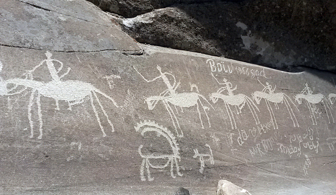
The Langar settlement and the petroglyphs of Pamirs
The colorful and picturesque Langar is located at the upper part of the Wakhan Corridor where the confluence of Wakhandarya and Pamir rivers create Panj River. Langar is famous with its granite rocks with variety petroglyphs – “the gallery of petroglyphs” consisting of more than 6 thousand pictures located above 2700-3500 m with various plots and ages: mountain goats, yaks, deer, hunters with dogs, archers, Buddhist buildings and so on. One of the favorite petroglyph of Pamiri people is the picture of the musical instrument rubab. It is believed that the picture of rubab depicts about the embodiment of human being and that’s why the pictures on stones remind us about people.
One of the interesting architectural plots is the picture of a religious staggered building mixed with the pictures of swastika and a headless demon flying over it. Probably such composition was painted not by accident nut on the contrary depicts about the intrusion of Buddhism in the territory of Badakhshan in the Kushan period and the evidence of it is the ruins of the monastery VI-VII c. several kilometers from Langar settlement in the village of Vrang.
Vebestdara
A great number of petroglyphs are located 30 kilometers from Khorogh town, in the Gunt gorge, above the Vebest settlement. The pictures are located above the summer pasture of Tir-yel at the snowy stripe boundary where the river flow out from the glacier.
The main plot of Vebestdara is the scene of hunting for the mountain goats – nakhchirs, galloping horse riders, battle plots, the scenes of capturing, running people, the moments of buzkashi (playing with a headless goat with abundant of horse riders), wedding procession and so on. A great amount of various solar signs and ornamented motifs, both the pictures of houses and yurts are found there.
Half of the petroglyphs are dated back to I thousand millennium BC particularly the scene of horse riders hunting to the wild yaks, and the rest of them belong to the Scythian and Sarmatia period when the Saks led a nomad's life in the territory of Pamirs and the most of it were painted in the medieval.
The Buddhist Temple of Vrang (V-VII c.)
One of the fascinating and interesting archaeological sites of Wakhan is the religious complex of Buddhist temple of V-VII century located above the Vrang settlement like a stark giant on top of a rock, at the right bank of Vrangdara. The temple is built with fortified walls and has rectangle buildings with sufas and fireplaces.
The fortified walls spread 80 m and the width is 1 m and there two towers on both sides with square base. There are eight premises inside connected to the walls and oriented to the entrance of the complex.
At the western part of it there are additional supporting walls at the edge of the cliff oriented to the direction of the light and there is a three staged tower “zikkurat” the base of which is laid up on a massive rock.
For the construction of the complex stones were mainly used for the base and raw bricks for the rest of the walls.
The complex which belongs to the Buddhist temple already was mentioned in many Chinese sources about the existence of the Buddhist temple in the Wakhan. However the archaeologist and the investigator of Pamirs Mir Bubnov supposes that the complex with supporters is a local Pamiri variant, where it is possible to find the oval chambers with the diameters of 3-4 m, served for pilgrimage campaigns which people gathered around the holly place.
The temple of fire in Zong (V-VII c.)
The temple is located on a small slope of a rock in Zong settlement. It consists of three parts built of slate blocks: the entrance yard is surrounded by walls and there is a deep fireplace in the eastern part. The premises of the temple are cross-shaped and there are niches and sufas in each of them. There is also a semicircular fireplace beneath of the sufas which refers to its religious identity. All those small premises have flat beam-type ceilings and the cross-shaped building might have a staggered “chorkhona” ceiling with a small window for smoke and light on top which is widely spread in the architecture of Badakhshan people.
Kuhilal (the ruby mountain)
The mountainous settlement of Kuhilal (the ruby mountain) is located at the western slopes of the Ishkashim ridge at the Panj river gorge known with its famous Badakhshani rubies – generous spinel quite similar to rubies and the sanguine garnet (karbunkul) and a new jewelry stone – chock like gummite. There were also found the variety of olivine – jewelry forsterite.
According to the law of Tajikistan “About the precious stones” in 2009 the generous spinel was added into the group of the first rate precious stones together with diamond, ruby, emerald, sapphire and aquamarine and others.
But the (jewelry) stone of chock like gummite was discovered by the French scientist Alfred Decluaso in 1876 from the Vesuvius Volcano. Since than it did not have much fame. Everything has changed in 1983 when in Kuhilal was discovered jewelry quality of chock like gummite among other crystals, though such mineral was already known in Badakhshan long time ago with the name of “mountain fire”. At that time Kuhilal was the only place where there were mined crystals like gummite and after then the weight of its mining was limited to 1-3 karat. But it is possible to find stones more than 20 karat there.
Besides spinel together with gummite there are also pyrite and enstatite.
The Karon town
The excavation of the ancient architectural and cultural monument of Karon was started recently in 2013.
The translation of “karon” from pehlavi is a place on top. In fact the town is 6 km from the center of Darvaz district Kalai Khumb as if looking to all from above, exactly from the Zogik Mountain.
The excavation and investigation of Karon since its discovery is not finished yet. Until now there were found the fragments of five domed temple, the temple of water, two temples of wind, wind mill, the fragment of the holly Zoroastrian book “Avesto”, the remnants of a pay ground for polo “chavgonbozi”, administrative and residential premises and also stone made objects with different geometric shapes were excavated from the ruins of the observatory.
There were excavated the ruins of fortresses from the ancient town, probably were the residences of the local kings.
The ancient Karon town was mentioned in the Arabic source as the IX century town, however the archaeological finds tell us that the Tajik ancestors lived here in the 3-2 thousand millennium BC during the epoch of the Arian civilization.
Afghan bazar at the bank of Panj river
The international Tajik and Afghan markets are not only the place of merchants and sellers of both parts of the borders but it is the touristic place of interest as well. By the initiatives and supports of the international organizations Afghan bazar was founded in 2009 for the stimulation of the economic relationship between the citizens of the border territory and this action was so fruitful that the next markets started their development. Nowadays four Tajik and Afghan markets are functioning in the territory of the Autonomous Mountainous Badakhshan Province: in the small district of Tem, city of Khorogh, in the center of Ishkashim district, in the village of Ruzvae of Darvaz and Khumrog of Vanj districts.
The Afghan sellers produce their hand made goods and the Tajiks offer their agricultural products.
Besides trade, markets and bazars are the best opportunities for the settlement of international business and peaceful coexistence. It is possible to have a cup of tea with bread here and to make a deal about the delivery of goods – buyers always need something.
If you see white tents and skullcaps at the both sides of the Panj River you should know, today the Tajik-Afghan bazar is working J.
Leave a comment